
Top Attractions in Fire Valley
The Valley of Fire State Park, situated in Southern Nevada, is a publicly accessible area that serves as both a nature preservation site and a recreational destination. As a part of the Nevada Desert, the park features fascinating rock formations, scenic roads, and breathtaking vistas. 
There are numerous activities to enjoy at the Valley of Fire, making it a worthwhile destination. A guided tour of the park is highly recommended, as it presents an opportunity to capture some stunning photographs.
Nevada’s first state park, the Valley of Fire, is a result of erosion and faulting that created the striking Aztec sandstone formations visible today. The fiery appearance of the park at sunset is due to the presence of iron oxide, silica, and manganese that shaped the formations. Human habitation of the area dates back 11,000 years, and the petroglyphs of the Basketmaker culture are among the many human-made artifacts that can be found etched into the black coating on the rocks, providing evidence of thousands of years of human history.
What to do at Fire Valley
You can visit the 40,000-acre Valley of Fire State Park on a day trip from Las Vegas—it takes just over an hour to reach the park from the Strip. The park offers a great variety of hikes that allow you to take in its natural wonders, like petrified trees, winding slot canyons, and formations, like Elephant Rock and the Beehives
How to Get There
If you are flying in from outside of Nevada, the nearest major airport is McCarran International Airport in Las Vegas. From there, you can rent a car and drive to the Valley of Fire, which is about an hour’s drive northeast of Las Vegas.
If you are already in Nevada, you can also drive to the Valley of Fire State Park from other cities in the state. For example, from Reno, you can take I-80 East to US-95 South and then turn onto NV-169 East to get to the Valley of Fire.
There are also guided tours available that can take you to the Valley of Fire from Las Vegas or other nearby cities.
Once you arrive at the Valley of Fire, you can explore the park on foot or by car, and there are several scenic drives and hiking trails to enjoy.
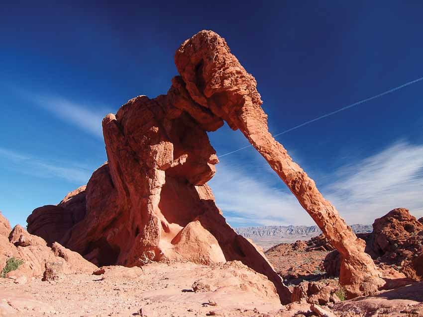
Elephant Rock
Its name is derived from its resemblance to an elephant, complete with a trunk and tail, which is a result of its distinctive shape.
Located near the East entrance of the park, this rock formation is a great spot for those interested in astrophotography.
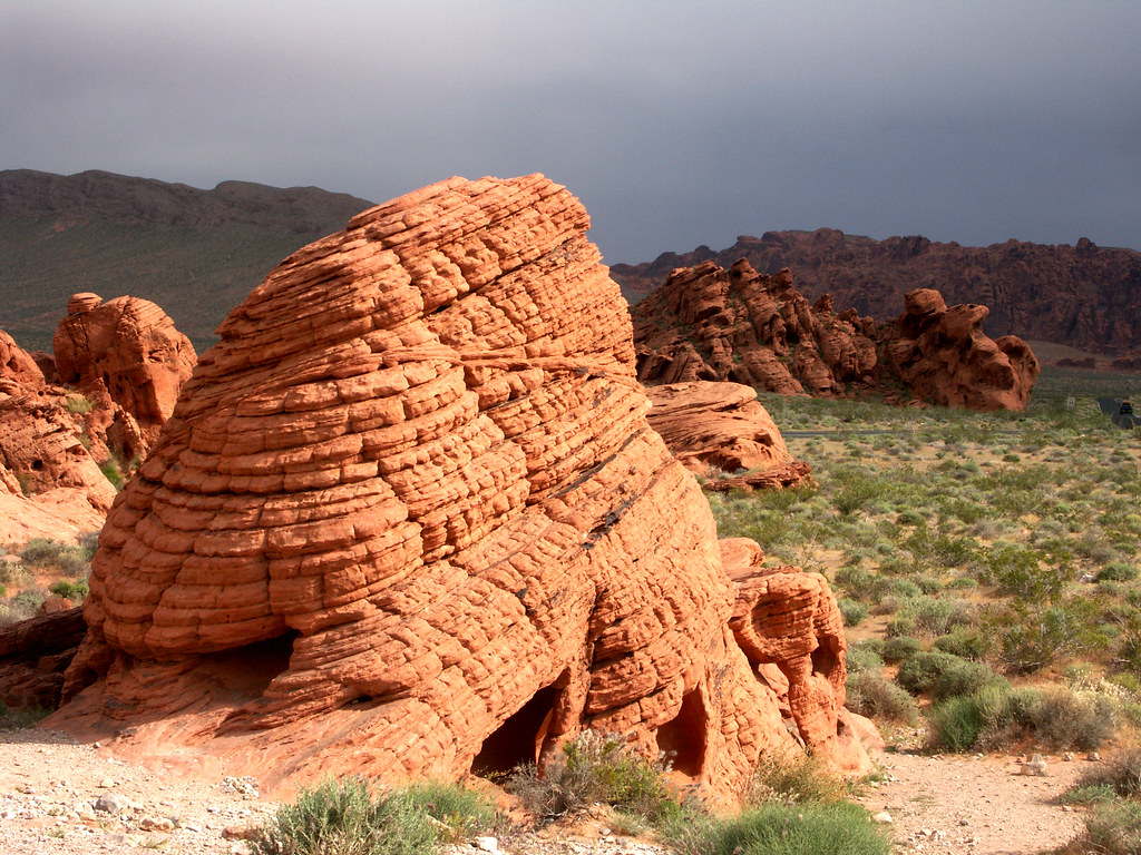
Beehives Center
This remarkable rock feature looks like an actual gigantic beehive and can be seen as soon as you enter the park, just off the main road.
Mouse’s Tank Road
The main road through the valley. A pleasure to drive

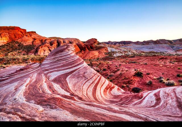
The Fire Wave
TThis 1.5-mile hiking spot leading to a rock formation resembles swirled ice cream! and feels like walking on a painting. Surreal.
Tips to Visit Fire Valley
If you’re planning a visit to Valley of Fire State Park, here are some tips to keep in mind:
- The best time to visit is between October and April when temperatures are cooler. Summer can be dangerously hot, with temperatures reaching up to 120 degrees F.
- Be prepared to pay an entrance fee at both park entrances ($10 for in-state vehicles and $15 for out-of-state), as National Park Passes are not accepted. Plan accordingly before you go.
- While the park only has two campgrounds inside the west entrance, free camping is available on Bureau of Land Management sites outside of the park on a first-come, first-served basis.
- Valley of Fire is dog-friendly, as long as you keep your dog on a leash no longer than 6 feet.
- Review the park’s hiking trail map before heading out on any trails.
- There are no food concessions in the park, so plan accordingly. For lunch, you can check out La Fonda Mexican Restaurant in Overton, which is located right before the turnoff to the west entrance of Valley of Fire.
Popular Hiking Trails in Fire valley
The Fire Wave Trail, spanning 1.5 miles, is a simple trek that commences in sandy terrain and navigates small rock piles along the slick rock formations to reach the base of the Fire Wave Rock. Due to crowds and high temperatures, it is advisable to start early and carry an ample amount of water.
The Petroglyph Canyon via Mouse’s Tank Trail is a popular hike that is approximately a mile long and celebrated for its petroglyphs. This trail leads you through a narrow box canyon that is adorned with petroglyphs created by the Basketmaker people. During the hike, you’ll come across numerous rock formations such as Elephant Rock and the Beehives, and a left-hand spur trail that leads to Mouse’s Tank, a smooth sandstone ledge that overlooks a pool of water.
The White Domes hike is a 1.1-mile loop that is heavily-trafficked and encompasses a slot canyon and vibrantly colored rocks, replete with small caves and windows. A recommended time to do this hike is after rainfall to observe an impressive display of wildflowers.
The Top of the World Arch Trail is a challenging 4.4-mile hike that necessitates expert orienteering abilities or the usage of GPS. The backcountry trail traverses unmarked footpaths and rock formations into the unspoiled wilderness. This hike is ideal if you desire solitude, breathtaking views, and wildlife sightings like bighorn sheep. It’s important to download a map and refer to it frequently.